Chris and John in South Carolina

Sunday, July 29, 2012

Oh Canada! June 3rd - Labrador City to Churchill Falls, LB


Day 6 - Sunday, June 3rd

During breakfast we visited with a fellow who told us that the odd area of boulevard and sidewalks we drove past the day before was all that is left of a town called Gagnon.  I remember seeing that name on the map and wondered why we hadn’t seen it during the drive.  Turns out it was a mining town, and when the mine closed down the mine owners were required to return the area back to its original state.  So they bulldozed everything, moved the workers to the new mine in Fermont and left only the boulevard and sidewalks.  I’m sure there were other scars from the mining operation, but we didn’t see them.  I guess you could call it a ghost town of sorts – except that the town itself was the ghost.

Our trip to Churchill Falls was paved the first two thirds of the way, and gravel the final third.  It was filled with more rugged scenery of amazing proportions.  We passed fewer bodies of water, and in fact seemed to be traversing a broad high plain for much of the way.  The trees were sparser and spindly.  We saw remains of the winter’s snow on higher peaks, in the shadows and around some of the lakes we passed.

The picture above and below give you an example of the VAST quantities of sand/gravel we saw!

This one gives you some sense of scale as to how big the gravel beds are.  Miles and miles of the stuff!

Much of the terrain this day was like this - flat scrubby wetlands.  The electric company used the device below to help secure their poles in the wet soils.


One of the beautiful shallow lakes we saw today.  


If you can look far ahead, you'll get a sense of the relatively flat, yet gently sloping road we traversed this day - at least until the pavement ran out...


A large area of the landscape had been burned by wildfires at some point in the past, and the areas still looked like forest graveyards.  We saw a fair amount of that on the way up to Labrador City as well. 
Remains of a forest fire.

Looking at the remnants of snow around the small island and along the far shor - as seen through the burnt shells from a forest fire.


One of the landscape features we found remarkable were the large areas covered with sub-angular/sub-rounded boulders of perhaps 3-4 feet in diameter – perhaps up to a cubic yard in size.  There were miles and miles of this stuff!  We remarked about how difficult it would be to walk across that kind of terrain.  I don’t know how the animals do it.


We tried to imagine the glacial process that laid down these vast craggy boulder fields.  How in the world would you traverse it?  Not easily, that's for sure.


Speaking of animals, we were getting a bit chagrinned about not seeing anything larger than a porcupine so far on the trip.  Chris wondered if it was difficult for them to cross the road given that the roadbed is raised 4 to 6 feet from the surrounding landscape across most of its length.  And the ditches were often deeper than the surrounding terrain.  

One does not want to go off the road.  Guaranteed rollover.  And we actually saw a couple of cars along the way that were on their tops in the ditch.  We stopped at the first one we saw, which looked like it happened just recently, to see if anyone needed help.  John said he saw a purse in there and a laundry basket filled with clothes, but no people or bodies.  Spooky.

As we approached Churchill Falls we crossed the Churchill River which was another interesting sight since the river pretty much isn’t there anymore – well, the river bed is there, but there isn’t any water coursing over it.  That’s because the river has been dammed.  So on the one hand, it was very interesting to see the bottom of the river which was scoured down to bedrock.  On the other hand, it was no use taking the hike to the Churchill falls, because there isn’t any water going over the falls anymore.


The Churchill River bed and the remains of the river.

What an odd place Churchill Falls is.  We gassed up and asked the way to the Midway Hotel.  A very nice lady said she’d drive us past the place if we’d like to follow her, which we did.  She told us Churchill Falls is a ‘company town’ essentially.  Everything in the town is owned by Nalcor, the company who owns and operates the hydro facility in Churchill Falls.  The only things they don’t own are the hotel, it’s restaurant and I think the grocery store.

I asked her if she was from Churchill Falls.  She replied, 'Oh goodness, no, dear.  I hope nobody my age is 'from' Churchill Falls'.

It’s possible to tour the electric facility in the town, and I understand it’s quite impressive, but we took a pass on that.

The Midway Hotel is in a large building called Town Center that also houses their school, grocery store, bank, restaurant and I’m not sure what else.  The houses all look modular – the easier to haul in, haul out and/or demo when they are no longer needed. 

The room was comfortable enough, but the walls were paper thin.  We had a jolly fisherman in the room next door who was pretty verbose, and we could hear every word he said.  It was ok when he was on the phone with is wife talking about his fun day of fishing.  But later, when he was talking with his buddies about girls that done him wrong, his political views on this and that, and dropping the F bomb every sentence, it got a bit old.  Fortunately there was an electric fan in the room which made some white noise.  And by 11pm or so, they quieted down.

Friday, July 27, 2012

Oh Canada! June 2nd - Manic 5, QC to Labrador City, LB


Day 5 – Saturday, June 2nd 

We sure are spoiled with our queen sized bed.  Sleeping in a double just doesn’t quite do the trick any more – especially since Chris likes to sprawl out and pushes poor Johnnie to the fringes of the bed.  Having a rough night sleep (for Chris anyway) made it especially difficult to get up at 4:15 in order to have an early breakfast and hit the road early in hopes of wildlife sightings.  John bounded right up, but Chris was a bit sluggish with no morning shower and only about 3 hours of sleep.  We were headed North again by about 5:30 in the a.m. breakfasted and bleary eyed - our destination, Labrador City.  

We crossed the 51st Parallel!


We drove past part of the enormous reservoir created by the Manic Cinq dam, but there is no public access to it – much to our chagrin.  It’s a protected area and only can be visited for research and educational purposes.  Rats!

Here is what we were able to see of it:


The reservoir made more obvious and visible the remains of an impact crater from eons ago.  That crater was then glaciated, I'm sure.  Water filled the crater leaving an island in the center.  The feature is striking when viewed on a map or aerially, and it is known as the Eye of Quebec. 

File:Manicouagan-EO.JPG
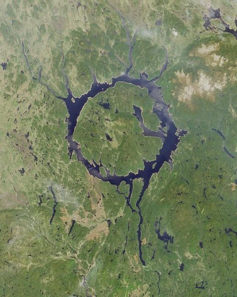
This is a NASA picture.  Our view of it was from the very right hand side of the circle.

According to a Wikipedia entry, here are some tidbits about the formation of this feature:

Manicouagan Reservoir (also Lake Manicouagan) is an annular lake in central Quebec, Canada. The lake covers an area of 1,942 km², and its eastern shore is accessible via Route 389. The lake island in the centre of the lake is known as René-Levasseur Island, and its highest point is Mount Babel. The lake and island are clearly seen from space and are sometimes called the "eye of Quebec." With a volume of 139.8 cubic kilometres (33.5 cu mi), the reservoir itself is the fifth largest in the world by volume
Manicouagan Reservoir lies within the remnant of an ancient eroded impact crater(astrobleme). The crater was formed following the impact of a 5 kilometres (3.1 mi) diameter asteroid which excavated a crater originally about 100 km (62 mi) wide although erosion and deposition of sediments have since reduced the visible diameter to about 72 km (45 mi). It is the fifth-largest confirmed impact crater known on earth.  Mount Babel is interpreted as the central peak of the crater, formed by post-impact uplift.
Research has shown that impact melt within the crater has an age of 214±1 million years. As this is 12±2 million years before the end of the Triassic, the impact that produced the crater cannot have been the cause of the Triassic-Jurassic extinction event.


We stopped in a place called Relais Gabriel where we found a place to pee and get more coffee.  John took a short nap in the car while Chris (who was finding her second wind by now) walked down by a pretty lake in back of the café. 


An impressive wood pile!


Point of interest:
Every bathroom we’ve been to in Canada, I don’t care how humble and out-of-the-way the establishment, has been very clean.  Puts the public potties in the U.S. to shame.


The highway to Labrador City was mostly gravel and very dusty.  At one point along the drive we came to an odd place with a short length of boulevard and sidewalks on either side of the road.  We were out in the middle of nowhere and it really seemed incongruous   Chris thought perhaps there were plans for a development that never panned out.  But we were able to walk along a short path down to - what else - a lake - and it was a nice break from the car.

I found these two fellows sunning themselves as we were walking around.
The creepy and the sublime!

It was another day of one gorgeous lake or stream or river after another – almost nonstop.  Unfathomable, really.  And almost none of them were accessible to us – not easily anyway.


We stopped at one river crossing and looked over the road bridge into the crystal clear shallow water.  As we gazed into the river we saw 5 BIG fish (trout?) lazily swimming near us.  They were headed upstream and seemed to let the current move them around from place to place, though they pretty much stayed near the bridge.  Now we understand why people like to come up here to fish.  You could almost reach in there and grab them they were so close.

We crossed the 52nd parallel!


And will you look at that sky!


One thing that struck us today was the amount of sand and gravel in the land around us.  Vast areas - miles and miles of seemingly nothing but sand and gravel under the fir trees.  What processes must have been at play to have created and amassed that much of it!

Another thing we noticed is the lack of understory.  The ground under the ‘skinny’ evergreens was very pale – almost white.  Turns out it is a kind of moss called caribou moss.  It is totally dry to the touch – John used the word skeletal to describe it.  When you step on it, it crushes practically to powder and leaves a distinct footprint.  This, we learned later, is an area of ‘taiga’ which is what you get prior to tundra.  There were miles and miles of this landscape.  We drove through it for hours.

This is a good example of the sand that underlies the vast landscape we drove through today.  See the crust on top?  Very interesting!

John checking out a benchmark as we explored the ground cover

I can't resist ground cover....


This, and the next few pictures below, show the color of the ground - the very light covering that is actually Caribou Moss - very dry and crunchy, but we understand it is an important food source for the caribou herds that live in the region.


The terrain is not what I’d call mountainous, but it does gain and lose elevation.  It just does so gradually and in broad sweeps rather than peaks and valleys.

As we approached Fermont, QC, on the border of Labrador, we began to notice railroad tracks and evidence of the large iron mines in the area.  The tracks literally glittered due to the crushed rock bedding.  The bedding comes from the native rock in the area which is rich in ‘sparkly’ components such as mica – John says it’s likely byotite and muscovite.  Chris filled her pockets and the vehicle with several representative examples of the stuff.

I wish this could have shown you how sparkly and pretty the crushed rocks along the road and rail bed were.  But, alas, my camera doesn't have a sparkly setting.


Here is a picture of the HUGE slag heaps the iron mining produces, but pictures really don’t allow you to appreciate the size.  They were enormous – truly.  Even what looks like mountains in the left background are slag heaps.  


And we passed by a settling pond where the water was literally salmon colored.  We were told it isn't poisonous, just a discoloration from the iron that settles in the pond.  Still, it's rather UNsettling to see.


More views of the slag heaps in the background


And so we come at last to Labrador!


(I love things that make me look small.)


Our respite for the night was the Two Seasons Inn and was quite pleasant.  We stocked up on lunch supplies at the IGA, gassed up the Highlander and tried to find any kind of craft shop open, but to no avail.  So we went back to the hotel, had dinner in their restaurant and went to bed.  I was surprised to hear a loon right outside our window.  There is a lake right next to the hotel (but then there are lakes EVERYwhere up there) and it was a nice little reminder of camp to hear the sound.


Point of interest:
Why is it called the Two Seasons Inn?  Labrador is lovingly referred to as the land with two seasons - Winter and Summer.  Apparently there is very little in the way of Spring and Autumn as transition seasons.

Thursday, July 26, 2012

Oh Canada! June 1st - Baie-Comeau, QC to Manic Cinq, QC


Day 4 – Friday, June 1st – Baie-Comeau,QC to Manic Cinq, QC

The fellow at the Hotel le Manoir desk told us when we checked in that we would see whales in the bay in the morning if the wind wasn’t blowing too hard.  And what do you know?  We DID see them in the morning!  We looked out our bedroom window and saw spouts several times.  We even saw the backs of a few whales at different times.  The same fellow told us that morning at breakfast that they were likely belugas and/or small black whales the name he didn’t know how to say in English.  We had a leisurely breakfast with our coffee and binoculars watching the gulf for any further sightings.  Then we packed up the Highlander and headed North for Manic Cinq – our next night’s stay.


Spout spotting

View from breakfast patio at Hotel le Manoir
Watching the ferry come in to port


We left the beauty of the St. Lawrence coast and headed North on highway 389 where it seems they can have a bit of road trouble in the winter.....
This essentially says that the roads between various points is closed if the light is blinking.

And you'd best be sure to have a full tank of gas before you had out....

that means there is gas in 1k, then not again for another 210k or about 126 miles


We passed by Manic 2 a short way north of Baie-Comeau


The landscape then changed quickly from coastal to one filled to overflowing with inland lakes and rivers.  I’ve never seen a land with more water in my entire life.  It’s hard to exaggerate the amount of fresh water Quebec has in the form of rivers, lakes, ponds, wetlands, etc etc.  If I were to take a picture of ever one of them we passed, I’d run out of film. And that’s hard to do with a digital camera.

Ready for some SERIOUS SWATTING!

Picture perfect day

Interestingly though, and different from the U.S., You cannot access most of the beautiful  rivers, lakes, ponds, wetlands, etc etc .  There aren’t public accesses or side roads that lead down to the water or anything like that.  It's just not geared for recreation, for the most part.  

AUTO 389 is a road that was built by, and is there to serve the needs of, Hydro Quebec - and that’s pretty much it.


It’s fine for people to use it, but it isn’t designed as a tourist road whatsoever.  It’s a totally utilitarian highway that just happens to run through one of the most beautiful places on God’s green Earth.

So we had to content ourselves with pulling off and taking pictures from the side of the road and wishing we could get closer to the water.  It was even hard to find a good place to stop for our lunch because we kept hoping we’d find a place where we could get close to a body of water and have a nice view while we lunched. 

I did, however, find these little beauties on one of my treks behind the bushes....


We crossed the 50th parallel today!


We drove for pretty much the whole day before we reached Manic Cinq and our hotel for the night, Motel de l’Energie.  The motel is geared primarily for people who work on the dam, not tourists.  We weren't sure what to make of the place when we first got there.  The buildings are very modular and the registration desk doubles as the checkout for the gas station and sundries store.  But the room was practically brand new and very clean and comfortable.  The only drawback is that it had a double bed – and that’s a bit small for us these days.  Chris needs lots of space to sprawl around and toss and turn.


Outside our room in a new modular unit.  


Manic Cinq, or Manic 5 is a dam.  A really really BIG dam.  In fact, it’s billed as the largest arch and buttress concrete dam in the world, standing 462 feet tall and having a thickness of 15 feet wide at the top and close to 200 feet thick at the bottom.  It’s pretty impressive to stand under it and see how big it is.  It’s even more impressive –maybe even a little scary – to see how close we could get to it.  I wonder if dams in the U.S. are that accessible to any John Q. Public who wants to walk up to them.


And here is the road we'd take the next morning north to Labrador City

Looking down the road from Manic 5

I had asked the fellow at Hotel Manoir in Baie Comeau the night before if he wasn’t a bit nervous being downstream from Manic Cinq.  I mean, if it let go…… He said that he had heard if the dam were to breach catastrophically, not only would it take out Baie Comeau, it would cause a big enough disturbance in the St. Lawrence River to take out the town on the south side of the river as well.  All the more reason that I found it a bit unsettling that we were allowed to get so close to it.

The dam is named after the Manicougan River and is called Manic Cinq because it is the 5th dam on the Manicougan River.  At least that’s what we were told by a local when we asked about it.  We also passed signs pointing directions to dams along the Outard River.  The Quebecois are not afraid to harness the power of their water, nosiree.

Manicougan River here and below


We saw our first wildlife today!  It was….. a Porcupine!  Yes indeed, the little fellow ambled across the road right in front of us and didn’t seem too perturbed about our big Highlander.  Hopefully there are still moose in our future on this trip.

Don't rush me!
And don't BUG me!
  
See, I told you I'd make it across ok. (This picture also shows the kind of road we'd be traveling for the next thousand miles or so - very sharp gravel.)

And then we saw another one who was equally as impressed with us as the first fellow.
Let me outta here, quick!  Wait - I can't move quick.  Rats!

Now go away and leave me be!


The restaurant at Motel de l'Energie had good basic food, but as we’ve noticed so far in Canada, it’s higher priced than we’re used to in the States.  Then add 13% taxes onto it – it adds up.  


We shared a piece of pie for dessert called sugar pie.  I had seen it listed on another restaurant’s menu also, so I rather think it’s a Canadian type of pie.  Anyway it was WONderful!  I may have to try making that myself when I have enough people to share it with so I don’t risk eating it all myself.


Here are a couple of links to recipes for the pie.  Whatever you do, don't look at the nutritional information.     : - )


http://allrecipes.com/recipe/miraculous-canadian-sugar-pie/

http://www.food.com/recipe/canadian-brown-sugar-pie-172758