Day 5 – Saturday, June 2nd
We sure are spoiled with our queen sized bed. Sleeping in a double just doesn’t quite do
the trick any more – especially since Chris likes to sprawl out and pushes poor
Johnnie to the fringes of the bed. Having
a rough night sleep (for Chris anyway) made it especially difficult to get up
at 4:15 in order to have an early breakfast and hit the road early in hopes of
wildlife sightings. John bounded right
up, but Chris was a bit sluggish with no morning shower and only about 3 hours
of sleep. We were headed North again by
about 5:30 in the a.m. breakfasted and bleary eyed - our destination, Labrador
City.
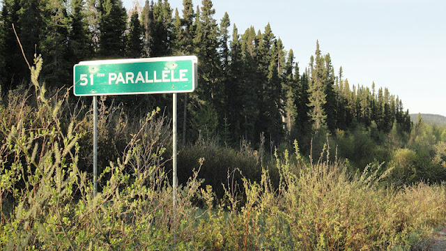
We crossed the 51st Parallel!
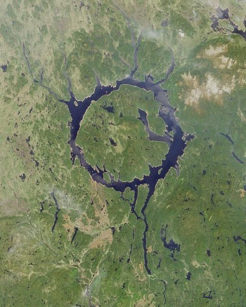
We drove past part of the enormous reservoir created by the Manic Cinq dam, but there is no public access to it – much to our chagrin. It’s a protected area and only can be visited for research and educational purposes. Rats!
Here is what we were able to see of it:
The reservoir made more obvious and visible the remains of an
impact crater from eons ago. That crater was then glaciated, I'm sure. Water
filled the crater leaving an island in the center. The feature is striking when viewed on a map
or aerially, and it is known as the Eye of Quebec.
 |
| This is a NASA picture. Our view of it was from the very right hand side of the circle. |
According to a Wikipedia entry, here are some tidbits about the formation of this feature:
Manicouagan Reservoir (also Lake Manicouagan) is an annular lake in central Quebec, Canada. The lake covers an area of 1,942 km², and its eastern shore is accessible via Route 389. The lake island in the centre of the lake is known as René-Levasseur Island, and its highest point is Mount Babel. The lake and island are clearly seen from space and are sometimes called the "eye of Quebec." With a volume of 139.8 cubic kilometres (33.5 cu mi), the reservoir itself is the fifth largest in the world by volume
Manicouagan Reservoir lies within the remnant of an ancient eroded impact crater(astrobleme). The crater was formed following the impact of a 5 kilometres (3.1 mi) diameter asteroid which excavated a crater originally about 100 km (62 mi) wide although erosion and deposition of sediments have since reduced the visible diameter to about 72 km (45 mi). It is the fifth-largest confirmed impact crater known on earth. Mount Babel is interpreted as the central peak of the crater, formed by post-impact uplift.
Research has shown that impact melt within the crater has an age of 214±1 million years. As this is 12±2 million years before the end of the Triassic, the impact that produced the crater cannot have been the cause of the Triassic-Jurassic extinction event.
We stopped in a place called Relais Gabriel where we found a
place to pee and get more coffee. John
took a short nap in the car while Chris (who was finding her second wind by
now) walked down by a pretty lake in back of the café.
 |
 |
| An impressive wood pile! |
Every bathroom we’ve been to in Canada, I don’t care how humble and out-of-the-way the establishment, has been very clean. Puts the public potties in the U.S. to shame.
The highway to Labrador City was mostly gravel and very
dusty. At one point along the drive we
came to an odd place with a short length of boulevard and sidewalks on either
side of the road. We were out in the
middle of nowhere and it really seemed incongruous Chris thought perhaps there were plans for a
development that never panned out. But
we were able to walk along a short path down to - what else - a lake - and it was
a nice break from the car.
 |
| I found these two fellows sunning themselves as we were walking around. The creepy and the sublime! |
It was another day of one gorgeous lake or stream or river
after another – almost nonstop.
Unfathomable, really. And almost
none of them were accessible to us – not easily anyway.
We stopped at one river crossing and looked over the road
bridge into the crystal clear shallow water.
As we gazed into the river we saw 5 BIG fish (trout?) lazily swimming
near us. They were headed upstream and
seemed to let the current move them around from place to place, though they
pretty much stayed near the bridge. Now
we understand why people like to come up here to fish. You could almost reach in there and grab them
they were so close.
 |
| And will you look at that sky! |
One thing that struck us today was the amount of sand and
gravel in the land around us. Vast areas - miles and miles of seemingly nothing but sand
and gravel under the fir trees. What
processes must have been at play to have created and amassed that much of it!
Another thing we noticed is the lack of understory. The ground under the ‘skinny’ evergreens was
very pale – almost white. Turns out it
is a kind of moss called caribou moss.
It is totally dry to the touch – John used the word skeletal to describe
it. When you step on it, it crushes
practically to powder and leaves a distinct footprint. This, we learned later, is an area of ‘taiga’
which is what you get prior to tundra.
There were miles and miles of this landscape. We drove through it for hours.
 |
| This is a good example of the sand that underlies the vast landscape we drove through today. See the crust on top? Very interesting! |
 |
| John checking out a benchmark as we explored the ground cover |
 |
| I can't resist ground cover.... |
The terrain is not what I’d call mountainous, but it does
gain and lose elevation. It just does so
gradually and in broad sweeps rather than peaks and valleys.
As we approached Fermont, QC, on the border of Labrador, we began to notice railroad tracks
and evidence of the large iron mines in the area. The tracks literally glittered due to the
crushed rock bedding. The bedding comes from the native rock in the area which is rich in ‘sparkly’ components such as
mica – John says it’s likely byotite and muscovite. Chris filled her pockets and the vehicle with
several representative examples of the stuff.
 |
| I wish this could have shown you how sparkly and pretty the crushed rocks along the road and rail bed were. But, alas, my camera doesn't have a sparkly setting. |
Here is a picture of the HUGE slag heaps the iron mining produces,
but pictures really don’t allow you to appreciate the size. They were enormous – truly. Even what looks like mountains in the left background are slag heaps.
And we passed by a settling pond where the
water was literally salmon colored. We were told it isn't poisonous, just a discoloration from the iron that settles in the pond. Still, it's rather UNsettling to see.
 |
| More views of the slag heaps in the background |

And so we come at last to Labrador!
 |
| (I love things that make me look small.) |
Our respite for the night was the Two Seasons Inn and was quite pleasant. We stocked up on lunch supplies at the IGA, gassed up the Highlander and tried to find any kind of craft shop open, but to no avail. So we went back to the hotel, had dinner in their restaurant and went to bed. I was surprised to hear a loon right outside our window. There is a lake right next to the hotel (but then there are lakes EVERYwhere up there) and it was a nice little reminder of camp to hear the sound.
Point of interest:
Why is it called the Two Seasons Inn? Labrador is lovingly referred to as the land with two seasons - Winter and Summer. Apparently there is very little in the way of Spring and Autumn as transition seasons.


Hi, I so loved reading this and really enjoyed the photos. I hope to travel this far north one day. Northern Canada including Labrador seems like such a beautiful, pristine place. Thanks for giving us this wonderful look at it!
ReplyDeleteThank you! I'm glad you enjoyed it, and I hope you do get a chance to visit up there. It's an amazing place. We went in June and did not have any problems with black flies or mosquitoes.
Delete